
Track Details - ID SELKLGJMT06-00X (Track 6)
Map Route
Loading map...
SECTION 1: General Information
Test Protocol:TP1, TP3, TP6, TP7
State:Selangor
District:Klang
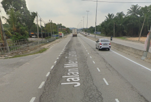
Road Name:Jalan Meru Tambahan
Geo Location Start:3.154079, 101.437009
Geo Location End:3.161688, 101.435992
Track Types:Rural
Surface Types:Dry
Distance (km):0.9
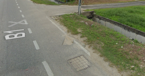
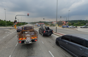
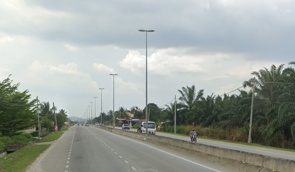
Track View Images


SECTION 2: Road Characteristics
Slope Description:Flat
Type of Road Divider:Concrete
Bumpers:No Marking
Irregularities:N/A
Type of Lane Marking:Single Dashed White Line
Lane Marking:Visible but Faded
Lane Width (m):3.5
Lane Width Description:Medium(<6m)
Overhead:No Overhead
Road Edge:Grass Shoulder
Roadside Features:Garbage Pile, Road Infrastructure
Controlled Straightaway Track Layout:Yes
SECTION 3: Lighting and Visibility
Light Source:LED Streetlight, Overhead Lighting From Petrol Stations or Public Facilities, High-Pressure Sodium
Dark Low Contrast Background:Moderate
Street Light Presence:Both Sides
Condition of Street Light at Night:Fully Functional
Visibility During Night Time:Moderate
Reflective Elements Presence:Reflective Signboards
SECTION 4: Traffic and Road Control
Peak Braking Coefficient:Dry Dirt Road
Traffic Light Type:Standard, Pedestrian
Traffic Light Description:Clearly Visible
Traffic Congestion Level (TCL) & Delay
| Time | TCL |
|---|---|
| 0700 to 1000 | Slight (2) |
| 1000 to 1300 | Moderate (3) |
| 1300 to 1600 | Heavy (4) |
| 1600 to 1900 | Severe (5) |
| 1900 to 2200 | N/A |
Vehicle Counts
| Time | Total Vehicle on The Road |
|---|---|
| 0700 to 1000 | 1820 |
| 1000 to 1300 | 473 |
| 1300 to 1600 | 686 |
| 1600 to 1900 | 2052 |
| 1900 to 2200 | N/A |
SECTION 5: Junctions and Roundabouts
Name of Junctions:Jln. Iskandar, Jln. Pasar Malam
Roundabout Type:No Roundabout
Junction Type:Slip Road Junction, One-Way Junction
Surroundings:Commercial Buildings, Residential Area Nearby, School or Public Facility, Traffic Signage and Road Markings Clearly Visible, Informal Vendors/ Stalls
Roundabout Characteristics:N/A
Junction Characteristics:Unsignalized T - junction
Distance to Nearest Roundabout/Junction:<=50m
Entry & Exit Deflection Design:Inadequate Entry, Well - Aligned Exits, Confusing Exit Paths
Visibility at Roundabout/Junction:Poor Visibility
Traffic Conflict Potential:Frequent Lane - Cutting
Description of Headway to Roundabout:N/A
SECTION 6: Environmental Conditions
Type of Surrounding Land:Residential, Commercial, Institutional, Undeveloped
Weather Condition:Dry and Clear
Noise Level:High
Surface Water Drainage:Moderate
Air Visibility:Light Haze
Wind Description:Calm
Ambient Temperature (°C)
| Time Period | Temperature (°C) |
|---|---|
| 0700 to 1000 | 28 |
| 1000 to 1300 | 31 |
| 1300 to 1600 | 30 |
| 1600 to 1900 | 30 |
| 1900 to 2200 | N/A |
SECTION 7: Pedestrian and Cyclist Considerations
Pedestrian Availability:Yes
Cyclist Availability:Yes
Pedestrian Users Age:19 - 29
Pedestrian Facilities:Sidewalks
Bicycle Infrastructures:None
Pedestrian Crossing Infrastructures:Informal Crossing, No Crossing Facility
Safety Measures:None
Pedestrian Presence Frequency
| Time Period | Frequency |
|---|---|
| 0700–1000 | Low |
| 1000–1300 | None |
| 1300–1600 | None |
| 1600–1900 | None |
| 1900–2200 | N/A |
SECTION 8: Infrastructure and Amenities
Amenities:Schools, Mini Markets, Restaurants, Food Stalls, Places of Worship
Infrastructures:Sidewalks
Accessibility of Amenities:Hard
Visibility of Amenities:Unclear Signpost
Cleanliness & Hygiene Facilities:Moderate
Seating & Shelter Availability:None
Utility Infrastructure Support:Street Lighting Poles
Safety & Security Features:Street Lighting
User -Friendliness & Inclusivity:Elder Friendly
WiFi & Mobile Connectivity:Strong Mobile Data Signal
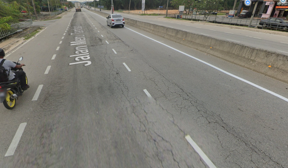
Roadside Images