
Track Details - ID NSJAT04-000Z (Track 4)
Map Route
Loading map...
SECTION 1: General Information
Test Protocol:TP4
State:Negeri Sembilan
District:Seremban
Road Name:Jalan Ampang Tinggi - Kuala Pilah
Geo Location Start:2.7467533, 102.2207247
Geo Location End:2.7403848, 102.2155172
Track Types:Rural
Surface Types:Dry, Paved
Distance (km):1.0
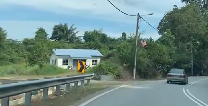
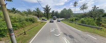
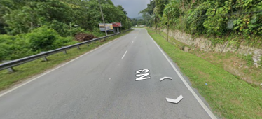
Track View Images
SECTION 2: Road Characteristics
Slope Description:Moderate
Type of Road Divider:Metal Barrier
Bumpers:Rumble Strips
Irregularities:N/A
Type of Lane Marking:Single Dashed White Line
Lane Marking:Clearly Visible
Lane Width (m):4.0
Lane Width Description:Medium(<6m)
Overhead:No Overhead
Road Edge:Grass Shoulder
Roadside Features:Signage / Street Furniture
Controlled Straightaway Track Layout:No
SECTION 3: Lighting and Visibility
Light Source:High-Pressure Sodium
Dark Low Contrast Background:Moderate
Street Light Presence:only One Side
Condition of Street Light at Night:Fully Functional
Visibility During Night Time:Moderate
Reflective Elements Presence:Reflective Signboards
SECTION 4: Traffic and Road Control
Peak Braking Coefficient:Dry Road ( Asphalt / Concrete )
Traffic Light Type:None
Traffic Light Description:Not Present
Traffic Congestion Level (TCL) & Delay
| Time | TCL |
|---|---|
| 0700 to 1000 | Slight (2) |
| 1000 to 1300 | N/A |
| 1300 to 1600 | N/A |
| 1600 to 1900 | N/A |
| 1900 to 2200 | N/A |
Vehicle Counts
| Time | Total Vehicle on The Road |
|---|---|
| 0700 to 1000 | 541 |
| 1000 to 1300 | N/A |
| 1300 to 1600 | N/A |
| 1600 to 1900 | N/A |
| 1900 to 2200 | N/A |
SECTION 5: Junctions and Roundabouts
Name of Junctions:N/A
Roundabout Type:No Roundabout
Junction Type:T Junction
Surroundings:Residential Area Nearby
Roundabout Characteristics:N/A
Junction Characteristics:Unsignalized T - junction
Distance to Nearest Roundabout/Junction:>50m
Entry & Exit Deflection Design:Inadequate Entry
Visibility at Roundabout/Junction:Clear Sightline
Traffic Conflict Potential:Smooth
Description of Headway to Roundabout:N/A
SECTION 6: Environmental Conditions
Type of Surrounding Land:Residential
Weather Condition:Dry and Clear
Noise Level:Moderate
Surface Water Drainage:None
Air Visibility:Clear
Wind Description:Calm
Ambient Temperature (°C)
| Time Period | Temperature (°C) |
|---|---|
| 0700 to 1000 | 28 |
| 1000 to 1300 | N/A |
| 1300 to 1600 | N/A |
| 1600 to 1900 | N/A |
| 1900 to 2200 | N/A |
SECTION 7: Pedestrian and Cyclist Considerations
Pedestrian Availability:No
Cyclist Availability:No
Pedestrian Users Age:None
Pedestrian Facilities:None
Bicycle Infrastructures:None
Pedestrian Crossing Infrastructures:No Crossing Facility
Safety Measures:None
Pedestrian Presence Frequency
| Time Period | Frequency |
|---|---|
| 0700–1000 | None |
| 1000–1300 | N/A |
| 1300–1600 | N/A |
| 1600–1900 | N/A |
| 1900–2200 | N/A |
SECTION 8: Infrastructure and Amenities
Amenities:Offices
Infrastructures:Residential Tracks
Accessibility of Amenities:Moderate
Visibility of Amenities:Not Applicable
Cleanliness & Hygiene Facilities:N/A
Seating & Shelter Availability:None
Utility Infrastructure Support:Street Lighting Poles
Safety & Security Features:Street Lighting, Guard Rails / Fencing
User -Friendliness & Inclusivity:Not Applicable
WiFi & Mobile Connectivity:Strong Mobile Data Signal
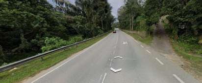
Roadside Images