

Track Details - ID KEDJSKJ01-0XYZ (Track 1)
Map Route
Loading map...
SECTION 1: General Information
Test Protocol:TP1, TP3, TP4, TP5
State:Kedah
District:Jitra
Road Name:Jalan Sungai Korok
Geo Location Start:6.2655576, 100.4193899
Geo Location End:6.260534679708195, 100.40654570307906
Track Types:Not Specified
Surface Types:Paved
Distance (km):1.5
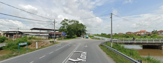
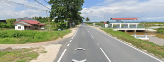
Track View Images


SECTION 2: Road Characteristics
Slope Description:Slight
Type of Road Divider:Concrete, Curb Divider
Bumpers:Bump Markers
Irregularities:N/A
Type of Lane Marking:Double Solid White Line, Single Dashed White Line
Lane Marking:Visible but Faded
Lane Width (m):3.5
Lane Width Description:Medium(<6m)
Overhead:Electric Cables
Road Edge:Painted Edge-Line, Grass Shoulder
Roadside Features:Vegetation Accessory, Signage / Street Furniture
Controlled Straightaway Track Layout:No
SECTION 3: Lighting and Visibility
Light Source:LED Streetlight
Dark Low Contrast Background:Moderate
Street Light Presence:Few and Scattered
Condition of Street Light at Night:Some Lights Not Working
Visibility During Night Time:Moderate
Reflective Elements Presence:Road Studs, Reflective Signboards
SECTION 4: Traffic and Road Control
Peak Braking Coefficient:Dry Road ( Asphalt / Concrete )
Traffic Light Type:Standard
Traffic Light Description:Clearly Visible
Traffic Congestion Level (TCL) & Delay
| Time | TCL |
|---|---|
| 0700 to 1000 | Moderate (3) |
| 1000 to 1300 | N/A |
| 1300 to 1600 | N/A |
| 1600 to 1900 | N/A |
| 1900 to 2200 | N/A |
Vehicle Counts
| Time | Total Vehicle on The Road |
|---|---|
| 0700 to 1000 | 907 |
| 1000 to 1300 | N/A |
| 1300 to 1600 | N/A |
| 1600 to 1900 | N/A |
| 1900 to 2200 | N/A |
SECTION 5: Junctions and Roundabouts
Name of Junctions:Jalan Sg. Korok- Jitra
Roundabout Type:No Roundabout
Junction Type:T Junction
Surroundings:Landscaping or Vegetation on Center Island, Commercial Buildings, Residential Area Nearby, School or Public Facility
Roundabout Characteristics:N/A
Junction Characteristics:Signalized T - junction
Distance to Nearest Roundabout/Junction:>50m
Entry & Exit Deflection Design:Confusing Exit Paths
Visibility at Roundabout/Junction:Minor Obstruction
Traffic Conflict Potential:Occasional Merging
Description of Headway to Roundabout:N/A
SECTION 6: Environmental Conditions
Type of Surrounding Land:Residential, Commercial, Agriculture
Weather Condition:Fog
Noise Level:Moderate
Surface Water Drainage:None
Air Visibility:Light Haze
Wind Description:Calm
Ambient Temperature (°C)
| Time Period | Temperature (°C) |
|---|---|
| 0700 to 1000 | 25 |
| 1000 to 1300 | N/A |
| 1300 to 1600 | N/A |
| 1600 to 1900 | N/A |
| 1900 to 2200 | N/A |
SECTION 7: Pedestrian and Cyclist Considerations
Pedestrian Availability:No
Cyclist Availability:No
Pedestrian Users Age:None
Pedestrian Facilities:N/A
Bicycle Infrastructures:N/A
Pedestrian Crossing Infrastructures:No Crossing Facility
Safety Measures:None
Pedestrian Presence Frequency
| Time Period | Frequency |
|---|---|
| 0700–1000 | None |
| 1000–1300 | N/A |
| 1300–1600 | N/A |
| 1600–1900 | N/A |
| 1900–2200 | N/A |
SECTION 8: Infrastructure and Amenities
Amenities:Schools, Convenience Stores, Restaurants, Food Stalls, Offices, Sport Facilities
Infrastructures:Residential Tracks, Parking Lots
Accessibility of Amenities:Moderate
Visibility of Amenities:Unclear Signpost
Cleanliness & Hygiene Facilities:Moderate
Seating & Shelter Availability:None
Utility Infrastructure Support:Electric Supply
Safety & Security Features:None
User -Friendliness & Inclusivity:Not Applicable
WiFi & Mobile Connectivity:Paid Wi - Fi Service, Strong Mobile Data Signal
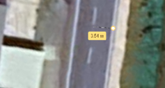
Roadside Images


